

Scotland’s railway gets a lot of weather. Although it is only 10% of the UK network, the region is 32% of the UK mainland and has the majority of its mountainous terrain.
The challenge of responding to severe weather events was tragically highlighted by the August 2020 Carmont derailment. As part of its response to this derailment, Network Rail set up weather advisory and management of earthworks task forces which were respectively led by Dame Julia Slingo and Lord Robert Mair. The reports from these task forces were summarised in issue 190 (May-June 2021).
The weather report considered how Network Rail could obtain the best possible weather forecasts and make best use of them. It noted that due to the chaotic nature of climate systems, best practice is to produce an ensemble of forecasts to assess the probabilities of a range of outcomes which are continually reviewed to provide increasingly narrower spread closer to the time of the forecast.
Both the earthworks and weather reports considered how weather forecasts need to be translated into infrastructure hazards to enable timely operational decisions to be taken.
At the time of the Carmont derailment, Network Rail’s weather advice used a 10km weather model that could not capture local extremes. Since then, there has been a rapid development of the company’s weather services.
Dame Slingo’s report considered that, prior to the Carmont derailment, Network Rail’s Extreme Weather Action Teleconferences (EWAT) were a static process, with limited capability to adjust alerts in an evolving weather situation. Furthermore, the weather thresholds for operational decisions, needed a major overhaul to reflect variations in exposure across the network.
Her report recommended that Network Rail should have access to a full range of weather forecasts and respond to them within the company’s existing (pre-Carmont) ‘Awareness – Preparedness – Response – Recover’ weather management framework which is shown below:
- Awareness – possible regional red weather alerts are recognised four to five days out.
- Preparedness – route controls assign red weather alerts two days out using kilometre-scale forecasts and begins to take preparatory action.
- Response – monitoring and alerting by nowcasting during extreme weather events.
- Recover – establish priorities and provide weather forecasts for recovery.
Implementing this framework requires both competent personnel and effective systems that clearly present relevant data to support effective decision making. The weather task force found that there was a gulf in expertise between those creating weather information and those receiving it. Hence it recommended that Network Rail should have a ‘weather academy’ to ensure its staff are well-informed users of weather services.
Dame Slingo’s report noted that, after Carmont, Network Rail has acted swiftly to improve preparedness for extreme weather events and their impact on earthworks, with the development of a Convective Alert Tool.
Scotland’s weather desk
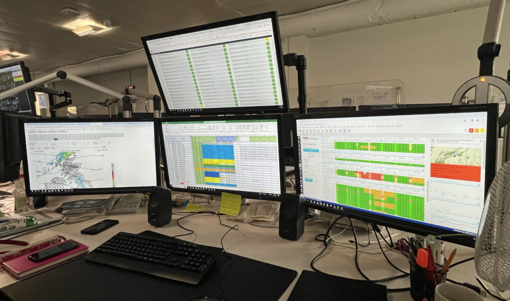
To find out how weather response works in practice, Rail Engineer was glad of the opportunity to visit Scotland’s control to speak to Karl Grewar, head of integrated control for Scotland’s railway, and Weather Operations Delivery Manager (WODM) Camilla Taylor.
Karl explained how Scotland has an integrated control with both Network Rail and ScotRail’s control teams reporting to him. Caledonian Sleeper and British Transport Police also have personnel in the control room. He advised that Scotland is the first Network Rail control to have an embedded weather desk staffed by professional meteorologists such as Camilla. This was originally set up in August 2021 and has been gradually established, partly because meteorologists are generally not available in Glasgow. The first meteorologists arrived in February 2022. To date, six have been recruited out of the full establishment of seven.
The importance of having weather professionals as part of the control has proved useful in enabling Scotland to have a targeted, rather than a blanket approach to weather mitigation. Karl explained that this had been done by moving away from number thresholds to take a more nuanced view of the mitigation required.
In the event of severe weather Karl advises that a system wide approach is needed that considers the ability to rescue trains and the risk to personnel called out to rescue trains. Lines will always be closed in the event of a Met Office red warning.
The weather plan
The extreme weather response specified in Scotland’s Adverse and Integrated Weather Plan (AIWP) follows the process recommended in Dame Slingo’s report (i.e. Awareness, Preparation, Response, Recovery and Review).
Awareness requires key stakeholders to be advised if the five-day forecast may warrant the issue of a red alert status when extreme weather thresholds are breached. These include: rainfall – daily above 40mm or hourly above 20mm; wind gusting over 60 mph; temperature exceeding 29°C; or snowfall exceeding 15cm. The required mitigation is finalised 24 hours beforehand and communicated to all concerned. This is the minimum period needed for the required mitigation to be put in place.
Customers also need to be given sufficient advice of the impact on their planned journey.
Preparation happens when a red alert may be warranted three days out on the five-day forecast or if the Control Manager has assigned a red alert two days out. This requires the convening of an Extreme Weather Action Teleconference (EWAT) to consider, amongst other things, the required mitigation. Infrastructure maintenance delivery managers are also required to convene a conference to review the potential weather impact and allocate resources accordingly.
Response requires the service and weather conditions to be monitored, the communication of developments to all concerned and action to be taken as required. If necessary, this includes further EWAT conferences if the weather deteriorates or affects unexpected areas.
Recover requires the control manager to convene recovery conferences to determine priorities and establish robust timescales for recovery of the network.
Review is done at a conference convened by the control manager to learn lessons from the response to the weather event and identify good practice.
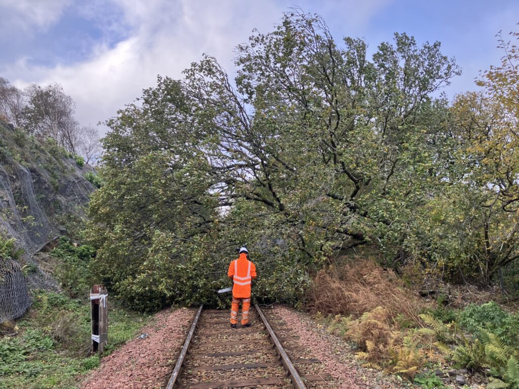
The AIWP considers the risks and mitigations for all types of extreme weather as well as seasonal arrangements for summer, autumn, and winter. It specifies weather precautions at specific locations which include structures at risk of scour and coastal defences. A section on tree management requires that, during extreme weather, the WODM shall review the impact of wind speed and direction on known hazardous trees recorded on the lineside tree survey.
A key aspect of the weather response is the use of Operational Route Sections (ORS). These are small route sections that are deemed to be at risk in severe weather which start and finish at clearly distinguishable points for drivers and signallers. During extreme weather, Blanket Emergency Speed Restrictions (BESR) are imposed on the affected ORSs. There are generally 40mph or 50mph restrictions which is the speed at which a train is most likely to remain upright if it strikes an obstruction. They can be as low as 20mph in the most challenging railway terrain areas.
The WODM
Camilla Tayler became an operational meteorologist in 2012 and had spent some years working in the aviation sector. She joined Network Rail Scotland as a WODM in October 2022. In our discussion it became clear that there is a significant distinction between assessing weather impacts on trains and planes. Whereas aviation meteorology is primarily concerned with the direct impact of the weather on aircraft, for rail the requirement is to assess how the infrastructure will be affected to assess the mitigation required to safely run trains.
For example, she notes how the impact of wind on trees has to consider wind direction and the season. In summer, when they have leaves, trees are more vulnerable at the same wind speeds that would be considered ‘normal’ at other times of year. This might, for example require a 40mph BESR when national thresholds don’t require any action. The risk of floods is related to run off which is depends on previous weather as run off is generally less when the soil is dry. However, after a period of hot weather when soils are baked dry, runoff can be very high particularly during intense rainfall when the rain doesn’t have time to sink in.
Camilla advises she uses her experience as a meteorologist to produce a forecast from Network Rail’s weather services together with various open source weather forecasts. At times of extreme weather, the WODMs are kept busy, frequently reviewing the forecast, and supporting EWATs. When there are no alerts the WODMs review previous extreme weather responses and help develop various mitigation measures. One such is a snow melt rate of flow model to predict flooding. Another is reviewing the risk from tunnel icicles.

Another aspect of the WODM’s role is monitoring the 80 earthwork sites where tilt monitoring has been installed. These transmit an alarm when there is a five degree movement though this may be due to disturbance by animals. If there is an alarm from two sensors, the line is closed pending an inspection. There are about 300 high-risk earthworks in Scotland.
She also mentioned Network Rail’s Weather Academy, the creation of which was one of the recommendations in Dame Slingo’s report. This has been established to provide operators and engineers with core skills for weather-based risk management and ensure that practitioners and meteorologists can understand each other. It has hosted a number of workshops and has its own homepage.
At the time of our discussion Camilla was updating the forecast and likely operational impacts for the weekend of 16-17 December for which the Met Office had issued a Yellow rain warning for north west Scotland. This presented a significant risk of flooding, potential for earthworks failures with risk of winds gusting over 50 mph on the West Highland line, Highland Mainline, Kyle, and Far North lines.
A wet weekend
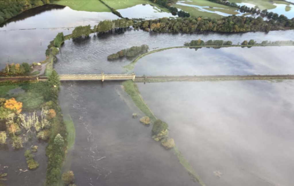
The weekend of 6-8 October was Scotland’s wettest two-day period since 1891, with an average rainfall of 64mm. This caused major rail disruption. It is understood that this was the first time that Scottish rail lines were pre-emptively closed due to forecast rainfall. In all such cases the resultant flooding would have closed these lines with the risk of trains being stranded.
This weather event was first forecast on Monday 1 October, and by Tuesday the weather model was forecasting widespread rainfalls of over 50 mm with some local rainfall of over 100 mm. On Wednesday, the WODM issued provisional BESR recommendations. With increased confidence in this forecast, following the EWAT conference on 5 October, key stakeholders were advised of the likelihood of pre-emptive line closures and widespread blanket speed restrictions. The plan for these closures and BESRs were finalised by 11:15 on Friday 6 October. Network Rail Scotland and ScotRail social media desks then used this information to pass on the ‘don’t travel’ message where lines were closed and ‘only travel if absolutely necessary’ on other lines.
The lines closed were the West Highland Line to Oban and Mallaig, the Highland Mainline between Perth and Inverness, and the North Clyde line between Dalmuir and Helensburgh. During the weekend, these lines were flooded and there was significant flooding in Glasgow and the central belt. The weather was closely monitored by the WODMs who issued three-hourly updates. During the weekend, the most severe impacts were not necessarily at locations with the highest rainfall but were related to river basin flooding in the Perth and the Fife areas due to high rainfall in their mountainous catchment areas.
In the West Highlands, where 100mm of rain fell during the day, the trunk road network was affected by seven landslips. The railway, which shares the same corridor, was pre-emptively closed due to the risk of landslips and was relatively unscathed.
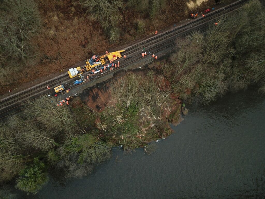
By late Saturday it became clear that it would not be possible to open some of the closed lines on Sunday 8 October as planned, as more rain than forecast had fallen in eastern Scotland. This led to further BESRs being required and resulted in a landslip near Cupar and washaway between Stirling and Perth where the line was blocked until Wednesday 11 October.
Changing climate
The Slingo report makes it clear there is no doubt that the UK is affected by climate change with increasing frequency of high-impact weather events. Records show that the earth is continuing to warm, with the decade to 2020 being the warmest on record. As warmer air holds more moisture (7% per 1°C change) there has been an increase in rainfall. In Scotland there has been an 8% increase in rainfall over the past decade compared with the long-term average.
Storm Henk in early January was the UK’s eighth since the start of the storm season in August. Furthermore, these storms are not the only extreme weather events. For example, the extreme rainfall experienced in Scotland on the weekend of 6-8 October was not the result of a storm. Neither was the high rainfall on the weekend of 15-17 December when the widespread BESRs were imposed.
Hence, infrastructure that had shown itself to be resilient to the UK’s past weather may now no longer be so. While much is being done to improve the UK rail network’s weather resilience, with much of its infrastructure being over 150-years old it is not possible to ensure that there will be no failures. Hence pro-active extreme weather mitigation such as line closures and BESRs is essential. Network Rail Scotland has shown how the effectiveness of this mitigation is enhanced by having embedded weather professionals in its control room.
Postscript
During storm Gerrit on 27 December, a ScotRail HST hit a tree at Broughty Ferry, north of Dundee on the line to Aberdeen. Fortunately, the driver was unharmed. Photographs on social media show this was a pine tree about 30 metres tall and around 15 metres outside Network Rail’s boundary. It was located on the esplanade and so was directly exposed to Gerrit’s southerly winds off the Firth of Tay which were gusting at up to 60mph.
As the tree fell, it pivoted around its root system and was supported by the ground around it which was slightly above rail level so that its trunk lay across the track suspended at cab height. In this particularly unfortunate circumstance, it was not surprising that the cab sustained significant damage when it hit this tall tree. The driver is reported to have escaped injury as he had time to leave his seat and move to the back of the cab.
This incident shows the importance of minimising this risk by imposing BESRs. At the time, a Network Rail press release advised that speed restrictions were planned for some sections of the line between Dundee and Aberdeen.
Preventing vulnerable trees that are well outside Network Rail’s infrastructure from falling onto the railway during extreme weather events is a significant challenge which, ideally, requires the adjacent landowner’s co-operation.
Network Rail is formally investigating the incident with its industry partners. The Rail Accident Investigation Board have also announced that they are to investigate this accident which occurred when the train was travelling at 84mph.
Rail Engineer would like to thank Karl Grewar and Camilla Tayler for their support with the production of this feature.